At its core, a solar panel inspection drone is a high-tech tool that pairs an unmanned aerial vehicle (UAV) with advanced thermal and high-resolution visual cameras. This combination allows for rapid, detailed surveys of solar farms, quickly pinpointing any defects that might be hurting performance. It’s a huge leap forward from the old way of doing things, trading slow, hazardous manual work for speed, safety, and incredible detail from the air.
Why Drones Are Shaking Up Solar Inspections
Let's be blunt: climbing onto roofs or trekking through massive solar farms to inspect panels by hand is outdated. It's a slow, painstaking process that puts technicians at risk of falls and electrical shocks. Worse still, it's often ineffective. On a large-scale solar farm, the sheer time it takes to walk the rows means you're only ever getting a small snapshot of the system's true health.
Trying to find a single faulty cell among thousands of panels under the hot Australian sun is a logistical nightmare. This old-school approach just isn't cutting it anymore, leading directly to operational bottlenecks and lost revenue.

A Bird's-Eye View with Aerial Intelligence
This is where solar inspection drones completely change the game. What used to be a week-long manual slog can now be an automated mission completed in a single day. By sending up a drone kitted out with a radiometric thermal camera and a high-resolution RGB sensor, asset managers get a complete, panel-by-panel health check of their entire facility.
By combining rapid aerial capture, standards-compliant thermography, and automated analysis, thermal drones transform inspections from a month-long manual ordeal into a data-rich digital workflow completed in days—or even hours.
From the air, these drones can precisely identify a whole range of issues, many of which are completely invisible from the ground:
- Hotspots that signal cell damage or failing bypass diodes.
- Micro-cracks and delamination that you can't see with the naked eye.
- Entire string outages causing significant power loss.
- Soiling, dirt, and encroaching vegetation that kill efficiency.
Huge Gains in Speed and Safety
It's no surprise that this technology is taking off across Australia—the benefits are just too good to ignore. A drone can survey a huge solar farm in a fraction of the time it would take a ground crew. This boost in efficiency doesn't just cut down on inspection time; it makes the whole process safer by keeping technicians firmly on the ground.
To really see the difference, a side-by-side comparison makes it clear.
Manual vs Drone Solar Inspections At a Glance
| Inspection Aspect | Traditional Manual Method | Drone-Based Method |
|---|---|---|
| Time Efficiency | Days or weeks for large sites | Hours or a single day |
| Safety Risks | High (falls, electrical shocks) | Minimal (operator on the ground) |
| Data Quality | Subjective, inconsistent, limited | Comprehensive, objective, highly detailed |
| Defect Detection | Misses subtle issues like micro-cracks | Identifies hotspots, cracks, soiling, and more |
| Coverage | Spot checks or partial inspection | 100% of all panels surveyed |
| Cost | High labour and insurance costs | Lower operational costs, faster ROI |
The table really tells the story. Moving to a drone-based workflow is a smarter, more effective way to manage solar assets.
Ultimately, using a drone for inspections is about more than just finding problems faster. It's about collecting comprehensive, actionable data that enables predictive maintenance and squeezes every last watt out of your system. For a broader look at how this fits into overall solar panel care, this comprehensive solar panel maintenance guide is a great resource. This modern approach helps secure a better return on investment and can significantly extend the life of your solar assets.
Getting Your Mission Plan Dialled In
Honestly, a successful solar panel inspection is won or lost before the drone even leaves the ground. It all comes down to the planning. Good planning is what separates getting accurate, useful data from just flying around and taking a few pictures. It's about thinking through the site, the gear, and the flight path before you even get in the car.
If you skip this part, you're setting yourself up for incomplete data, wasted time, and maybe even a few safety scares. It’s the groundwork that makes everything else run smoothly.
This flow chart gives a great overview of what a well-planned mission looks like, from the first checks right through to creating the final flight path.
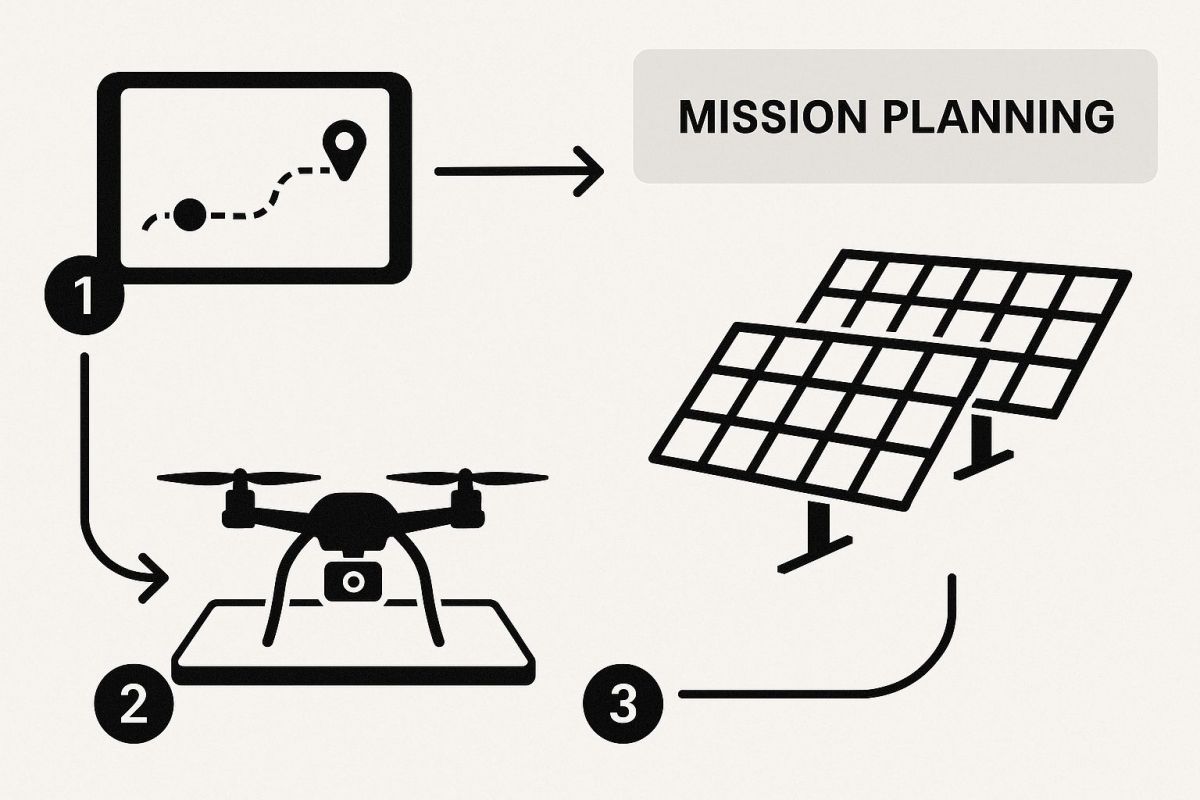
As you can see, it's a series of deliberate steps, not just one single flight.
First Things First: A Solid Site Assessment
Before you even think about flying, you need to understand the environment you're walking into. A proper site assessment involves checking things out on a map and then getting your boots on the ground to spot any risks or challenges.
Your first port of call should always be the airspace. Here in Australia, that means firing up a CASA-verified drone safety app to check for flight restrictions, controlled airspace, or nearby aerodromes. Catching these early saves a world of compliance headaches later.
Next, you need to walk the site and look for ground-level hazards. I’m talking about:
- Power lines and comms towers: These can mess with your drone’s signal or, worse, become a collision risk.
- Rough terrain: Find a nice, flat spot for your take-off and landing zone. Don't try to be a hero on a steep slope.
- Local wildlife: Especially on rural sites, keep an eye out for birds that might take an interest in your drone.
- Site access: Make sure you can get to where you need to be without getting in the way of the facility’s day-to-day operations.
A tip that’s often missed: check the weather forecast for more than just rain. You need to look at wind speed and, crucially, solar irradiance. To get reliable thermal data, you really want a steady irradiance of at least 600 W/m² with as little cloud cover as possible.
Choosing the Right Drone and Payload
The gear you choose has a massive impact on the quality of your inspection data. While the drone itself needs to be a solid, reliable workhorse, the real star of the show is the sensor payload. For solar inspections, a dual-sensor setup is pretty much the industry standard.
This means you’ll need a radiometric thermal camera. This kind of camera doesn’t just show you heat; it actually measures the exact temperature of every pixel. That's how you identify hotspots and other thermal problems with real, hard numbers. You'll also want a high-resolution RGB camera so you can see what’s actually going on – things like dirt, cracks, or physical damage that might be causing the thermal issue.
Automating Your Flight Plan
Let's be real, manually flying a drone over thousands of panels is a recipe for disaster. It's slow, inconsistent, and you’re bound to miss things. This is where automated flight planning software is an absolute game-changer. Tools like DroneDeploy, Propeller, or Pix4D let you map out a precise, repeatable flight path that the drone follows on its own.
Getting the flight plan right ensures you cover every single panel and get the best possible data. If you want to dig deeper into what's out there, you can learn more about choosing the right UAV flight planning software for your specific needs. The aim is to set your parameters—like altitude and image overlap—to guarantee every panel is captured clearly. A good rule of thumb is to aim for at least 70% image overlap to ensure your final stitched-together map is accurate and detailed.
Putting Your Drone in the Air for Top-Quality Data
Alright, you've got your mission plan sorted. Now for the fun part: getting the drone airborne and putting that plan into action. This is where all that careful preparation really pays off. A smooth, safe flight is what translates your planning into the high-quality data you need for a proper analysis. It all comes down to a disciplined approach, from your final checks on the ground to keeping a sharp eye on the mission once it's underway.
Those few moments before you launch are your last chance to spot a problem before it becomes a bigger one. Running through a pre-flight checklist isn't just a box-ticking exercise; it's fundamental for safety and getting usable data. Before every single flight, give the drone a proper physical inspection. Look for any wear and tear, make sure the propellers are on tight, and double-check that every battery—for the drone and the controller—is fully charged and healthy.

Final Checks and Watching the Weather
The weather is always the biggest wildcard. For a thermal inspection, you’re looking for a perfect storm of good conditions: clear skies, minimal wind, and consistent sunshine. You need a steady energy load hitting the panels so that any hotspots or anomalies really pop in the thermal imagery. A good rule of thumb is to fly only when the solar irradiance is at least 600 W/m². Flying with scattered clouds rolling through is a recipe for disaster, as the panels will constantly heat and cool, making your thermal data a messy, unreliable jumble.
Before you even think about taking off, run through these final tech checks:
- Calibrate Your Sensors: Make sure both the thermal and standard RGB sensors are calibrated exactly as the manufacturer recommends. Don't skip this.
- Get a Solid GPS Lock: Be patient and wait for the drone to lock onto multiple satellites. If you're using an RTK system, this is where you get that centimetre-level accuracy that’s so crucial for precisely geotagging your images.
- Load the Right Mission: Sounds obvious, but always double-check that the correct automated flight plan is loaded and ready to go in your controller.
Launching and Keeping an Eye on Things
Once you've ticked all the boxes, it's time to launch the automated mission. The drone will handle the rest—taking off, flying to the first waypoint, and methodically flying the grid pattern you programmed. But just because the drone is flying itself doesn't mean your job is done. You're still the pilot in command. You need to maintain a visual line of sight and actively monitor the drone’s progress from start to finish.
Keep your eyes glued to the live telemetry data on your controller. You’ll be watching flight speed, altitude, battery life, and of course, the live video feed. This is how you confirm the drone is sticking to the right altitude and maintaining the overlap you need for clean data. If you want to get a better sense of how it all works together, understanding the drone camera and gimbal relationship shows you how these components create that stable, crystal-clear imagery.
Here’s a pro tip from the field: as the drone flies its pattern, watch the live thermal feed. If you suddenly see an entire string of panels go cold, it could be a sign of a bigger problem like a blown fuse or an issue with a combiner box. That's something you'll want to investigate further.
Knowing When to Take Over
Automated flights will handle 99% of the job, but there are always moments that call for a human touch. If you spot a major thermal issue or obvious physical damage on the live feed, don't hesitate to pause the mission.
This is your chance to take manual control, fly in for a closer look, and snap some high-resolution photos of the specific area. Once you’ve got the detailed shots you need, you can simply tell the drone to resume the automated mission right where it left off. This hybrid approach gives you the efficiency of an automated flight with the diagnostic power of a hands-on inspection, ensuring you not only find the faults but also have the evidence to fix them.
Turning Drone Data Into Actionable Insights
Once your drone is safely back on the ground, the real work begins. You're now sitting on a massive dataset of high-resolution visual and thermal images, sometimes thousands of them. But the value isn't in the individual photos; it's in the story they tell when you piece them all together. This is where you transform that raw data into a clear, prioritised maintenance plan.
The first job is to process all those images and build a comprehensive digital map of the entire solar farm. Specialised software takes every geotagged photo and stitches them together into what’s called an orthomosaic—a single, high-resolution, and geographically perfect map of the site. It gives you a bird's-eye view that’s incredibly detailed and perfectly aligned with the real world.
Stitching the Data Together
Creating this map is a crucial step. The software cleverly analyses the high overlap between your photos to align them perfectly, automatically correcting for any distortions from the camera angle or the lay of the land. You’ll end up with two main assets: a visual orthomosaic from your standard RGB camera and a thermal orthomosaic from the infrared sensor.
These two maps can then be layered on top of each other. This lets you instantly switch between a real-world view and a thermal heat map for every single panel on the site. If you want to get into the nitty-gritty of how this works, our overview on drones and GIS breaks down the connection between aerial imagery and geographic information systems. This integrated view is the foundation for everything that comes next, giving you the context to pinpoint the exact location of any fault.
Innovation in this space is moving fast, especially here in Australia. For example, Lab360 Solar, a start-up from the University of New South Wales, recently secured AUD 3.96 million in funding from the Australian Renewable Energy Agency (ARENA). They're refining Daylight Photoluminescence imaging on drones to find panel faults with far greater precision. It’s a great example of the strong local investment pouring into this technology.
Identifying Common Faults From the Air
With your digital maps ready, you can start hunting for anomalies. Different types of faults create distinct thermal signatures that really stand out from an aerial view. A lot of the analysis software today uses AI to automate much of this, flagging potential issues for you to review more closely.
The real goal of post-flight analysis is to go beyond just finding faults. It’s about categorising them by severity, figuring out the likely cause, and building a prioritised action plan that sends maintenance crews to the highest-impact repairs first.
So, what are we looking for? Here are some of the most common issues you'll spot and what they look like in your data.
Common Solar Panel Faults and Their Thermal Signatures
Learning to spot the tell-tale thermal patterns of common solar panel problems is a key skill. The table below breaks down some of the most frequent faults, what to look for in your thermal imagery, and what might be causing them.
| Fault Type | Thermal Signature Description | Potential Cause |
|---|---|---|
| Hotspots | A single cell or a small cluster of cells appearing much hotter than their neighbours. | Internal cell defects, micro-cracks, or a failing bypass diode. |
| String Outages | An entire row of panels looking uniformly cool or showing the same ambient temperature. | Could be a blown fuse, a tripped breaker, or a disconnected cable in the combiner box. |
| PID (Potential Induced Degradation) | A checkerboard or diagonal pattern of hot cells across a single module. | Usually caused by voltage leakage between the cells and the panel frame, leading to power loss. |
| Soiling and Shading | Cooler patches or distinct shapes on a panel’s surface that seem to follow a pattern. | Dust, bird droppings, dirt build-up, or shadows from nearby trees or structures. |
| Delamination | Irregular, patchy hotspots that can look like "snail trails" spreading across the panel surface. | Moisture has gotten into the panel, causing its layers to separate and creating resistance. |
By getting familiar with these visual cues, you can quickly diagnose the health of an entire solar farm from your desk. It turns a simple data-gathering flight into a powerful diagnostic tool, driving real improvements in energy output and helping your assets last longer.
Where Solar Maintenance in Australia is Heading
The game is changing. Solar maintenance is no longer just about finding things that are already broken. The real frontier, where the smart money is going, is in prediction. We're seeing a much deeper fusion of AI and thermal drone data, which is giving asset managers a crystal ball to see potential failures long before they cripple a system. Maintenance is shifting from a reactive chore to a genuinely proactive strategy.
Think about it this way: instead of just getting an alert about a hotspot, future systems will track how that spot's temperature changes over multiple inspections. This kind of trend analysis can predict how much life a panel has left or flag a bypass diode that's on its last legs. This allows for planned, optimised replacement schedules, cutting downtime to an absolute minimum.
The Rise of Full Autonomy
This predictive power is being coupled with another massive leap: fully autonomous 'drone-in-a-box' systems. Picture a weatherproof docking station sitting permanently on the edge of a large-scale solar farm. It can deploy a drone on a set schedule—say, every Tuesday at 10 AM—or whenever the weather conditions are just right for a perfect thermal scan. The drone does its job, flies back, recharges, and uploads the data, all without a human touching it.
This completely removes the need to send a pilot out to remote sites, which unlocks some serious benefits:
- On-Demand Inspections: You can react instantly to a performance dip or a system alert.
- Consistent Data: Every flight follows the exact same path and parameters, making the data perfect for spotting subtle changes over time.
- Reduced Costs: It dramatically slashes the labour and travel costs tied to manual inspections.
At the end of the day, bringing a drone into your solar inspection workflow isn't just an operational upgrade. It's a strategic investment in the long-term health, efficiency, and profitability of your renewable energy assets. It puts you at the front of the pack.
This evolution isn't just happening in the sky, either. On the ground, we're seeing huge strides in advanced solar panel cleaning equipment, including automated robotic systems, all pushing for greater efficiency.
The numbers back this up. The global market for drone solar inspections hit USD 620 million in 2024, and that's only expected to grow as the tech gets better and government policies favouring renewables continue. You can dig into more of those trends over at Credence Research's global market report. For us here in Australia, getting on board with these advancements is crucial if we want to lead the charge in smarter, more efficient energy production.
Got Questions About Drone Solar Inspections?
Whenever you're looking at bringing new tech into your workflow, you're going to have questions. It’s only natural. For solar asset managers and technicians eyeing up drones for panel inspections, a few key topics pop up time and time again. Let's clear the air on some of these common queries.
Is it Really Worth the Cost?
The first thing most people ask is about the money. Is the investment in a drone and training actually going to pay off? The short answer is yes, and usually faster than you'd think. Drone inspections are often around 40% cheaper than sending a team out to walk the site.
Think about it: you slash labour hours, and you don't have to shut down entire arrays for inspection. This means you get a far more detailed look at your asset's health without losing a single watt of generation.
How Accurate Can a Drone Be From Up There?
Another common question is about accuracy. Can a drone flying at 50 metres really match what a tech can see on the ground? Absolutely. Modern radiometric thermal cameras are incredible pieces of kit. Each pixel in the image isn't just a colour; it's a precise temperature measurement. This data lets the software automatically flag anomalies that fall outside the manufacturer's normal operating range.
Navigating Australian Drone Regulations
For any commercial drone work in Australia, you've got to play by the rules set by the Civil Aviation Safety Authority (CASA). The regulations might seem a bit daunting at first, but they’re all about keeping everyone safe.
For most large-scale solar farm inspections, your pilot will need a Remote Pilot Licence (RePL), and the business itself needs a Remotely Piloted Aircraft Operator's Certificate (ReOC). These are the official ticks of approval that show your team is properly trained and has solid, safe procedures in place.
Don't ever be tempted to cut corners here. Flying a drone for commercial gain without the right CASA certifications is illegal and comes with some hefty penalties. For professional solar asset management, you either partner with a certified operator or invest in getting your own team trained up. There's no middle ground.
This framework is what ensures every flight is conducted professionally, with a full understanding of airspace rules and potential hazards.
So, What Faults Can a Drone Actually Find?
This is where the technology really shines. Thermal drones can spot a huge range of issues, many of which are completely invisible to the naked eye. They're brilliant at pinpointing defects that are quietly killing your farm's performance.
Here’s a quick list of what a typical thermal drone inspection can uncover:
- Hotspots at the cell level, which can signal internal damage or a failing bypass diode.
- Entire string outages, immediately pointing you towards a likely blown fuse or a combiner box fault.
- Potential Induced Degradation (PID), which often appears as a tell-tale checkerboard heat pattern across a panel.
- Physical damage, from tiny micro-cracks and delamination to soiling from dust or bird droppings.
By capturing these thermal signatures from the air, you get a comprehensive health check for every panel on site. This data empowers your maintenance crews to shift from just reacting to failures to proactively fixing small issues before they snowball into major production losses. It's all about securing the long-term efficiency of your asset.
At Innoflight International, we provide the advanced, reliable drone platforms and sensor payloads needed to carry out precise and efficient solar inspections. Discover our range of solutions designed for Australian conditions. Explore our drone solutions.