At its heart, UAV flight planning software is the brain of your drone operation. It’s what turns your UAV from a simple remote-controlled aircraft into a sophisticated, automated tool for gathering data. You essentially draw a flight path on a map, telling the drone exactly where to fly, how high to go, and what to look at.
The Brains Behind Automated Drone Missions
Think of this software as a digital choreographer for your drone. Instead of trying to manually fly a perfect grid pattern over a large area – a task that’s incredibly difficult and prone to error – the software creates a precise set of instructions for the drone to follow before it even takes off. This is the crucial step that makes complex, large-scale drone missions not just possible, but also repeatable and safe.
This technology is a game-changer for industries all across Australia. Whether it’s a farmer monitoring crop health in the Riverina or an engineering firm inspecting a bridge in Sydney, the software ensures every flight is as efficient and accurate as possible. It crunches all the complex numbers in the background, letting the operator focus on the bigger picture: the mission’s goals.
Why Is This Software So Important?
Fundamentally, this software swaps out manual guesswork for mathematical precision. For any professional job where accuracy and consistency are paramount, this isn’t just a nice-to-have; it’s essential.
Imagine a surveyor trying to build a 3D model of a new housing development. They need hundreds of photos taken with a specific overlap from a consistent height. Doing that by hand over several hectares would be a nightmare. The software automates the whole thing, guaranteeing the right data is captured every time.
This kind of operational reliability is what’s fuelling the massive growth in the commercial drone industry. In Australia alone, the sector was valued at around USD 0.28 billion in 2024. Projections show it’s set to explode, with a compound annual growth rate (CAGR) of 27% from 2025 to 2034, spurred on by its adoption in agriculture, construction, and mining. You can explore more data on Australia’s drone market growth and see what’s driving this trend.
Key Takeaway: UAV flight planning software isn’t about making things easier; it’s about setting a higher standard for data collection. It transforms the drone into a reliable industrial instrument, capable of pulling off complex jobs with a level of precision manual flying simply can’t touch.
By automating the flight path, you can ensure every inch of an area is covered, keep flight times to a minimum, and dramatically cut down on the risk of human error. This efficiency leads directly to lower running costs and better results for clients, making it a cornerstone of any serious professional drone operation.
Key Features to Look for in Modern Drone Software
When you’re trying to pick the right UAV flight planning software, the sheer number of options and technical terms can be overwhelming. But if you cut through the noise, you’ll find a handful of core features that make a real difference in the field, turning complicated jobs into smooth, safe, and efficient missions. Getting to know these features is the first step to choosing a platform that’s genuinely built for professional work.
At the heart of any good software are automated flight modes. These are the pre-set flight patterns that allow the drone to cover an area with a level of precision that a human pilot simply can’t match.
- Grid Patterns: Think of this as your go-to for creating detailed 2D maps. The software tells the drone to fly back and forth, like mowing a lawn, making sure every photo overlaps perfectly. This is absolutely essential for accurate surveying and mapping.
- Corridor Scans: This one is a lifesaver for inspecting long, linear assets like pipelines, roads, or powerlines. It creates a focused flight path that follows the asset, keeping it centred in the frame to ensure you capture every detail from start to finish.
- Orbital Flights: Need a high-fidelity 3D model of a building or a stockpile? This is the mode you’ll use. The drone flies in circles around your target at different heights, capturing it from every possible angle for a complete digital reconstruction.
It’s these kinds of intelligent, automated features that are fuelling the incredible growth of Australia’s commercial drone industry. The market, which relies heavily on this kind of advanced flight software, was valued at around USD 772 million in 2023 and is projected to soar past USD 2.09 billion by 2032. This boom is happening because the software makes complex, data-heavy missions repeatable and reliable.
Visualise the Mission, Maximise the Safety
Great software does more than just tell a drone where to fly; it acts as a digital co-pilot, with safety at its core. One of the most critical safety tools you’ll find is the 3D mission preview. This feature lets you run a virtual simulation of the entire flight path before you even think about taking off.
The image below gives you a sense of how central this route planning is to any professional drone operation.
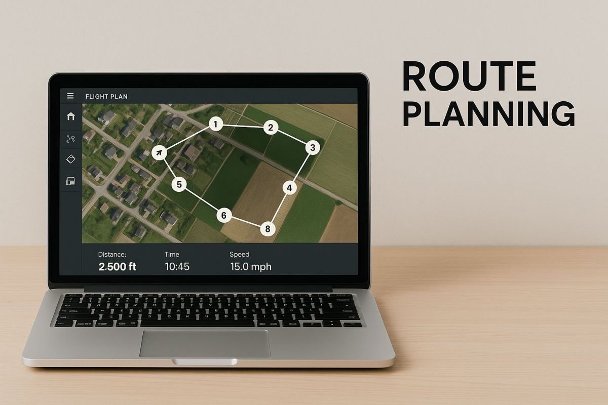
This kind of interface gives you a clear, top-down view to map out your waypoints and check every part of the mission. It’s far from a gimmick—this preview helps you spot potential clashes with terrain, buildings, or other obstacles that you might easily miss on a standard 2D map.
A solid no-fly zone (NFZ) database is another non-negotiable. Top-tier software automatically pulls in the latest data on restricted airspace, airports, and other sensitive locations. It will physically stop you from even planning a flight that might break the rules, acting as a crucial safety net to keep you compliant and responsible.
To give you a clearer picture, here’s a quick breakdown of the essential features and why they matter.
Essential UAV Flight Planning Software Features
| Feature | Primary Benefit | Example Use Case |
|---|---|---|
| Automated Flight Modes | Increases data consistency and mission efficiency. | Flying a perfect grid pattern over a farm to collect data for a crop health analysis. |
| 3D Mission Preview | Allows for pre-flight risk assessment and obstacle avoidance. | Simulating a flight around a communications tower to ensure the drone won’t clip guy-wires. |
| Integrated NFZ Database | Ensures regulatory compliance and prevents accidental airspace incursions. | The software flags a planned flight path that’s too close to a local airport’s approach path. |
| Real-Time Telemetry | Provides live data on drone status (battery, GPS, speed) for in-flight monitoring. | A pilot notices a sudden drop in battery voltage and safely brings the drone home early. |
| Customisable Checklists | Standardises pre- and post-flight safety procedures. | Forcing a pilot to confirm “propellers secure” and “GPS lock acquired” before takeoff is enabled. |
By focusing on these practical automation and safety features, you can make a much more informed decision. If you’re looking to see how these elements come together in a complete ground control station, checking out the new flight planning software i-GCS from Innoflight is a great way to see them in action. This will help you confidently choose a platform that has the reliability your professional work demands.
How Flight Planning Improves Drone Operations
Using proper UAV flight planning software is about much more than just hitting an ‘auto’ button. For professional drone teams, it delivers a real, measurable return on investment. It takes tasks that were once manual and prone to mistakes and turns them into precise, repeatable missions, which completely changes the game for efficiency, safety, and the quality of data you collect.
Think about the difference between navigating with an old paper map and using live GPS on your phone. You can probably get where you’re going with either, but the GPS finds the best route, dodges traffic jams, and gives you live updates. It just makes the whole trip predictable and smooth. Flight planning software does exactly that, but for your drone.
This move towards automated control is a big reason why drones are being adopted so seriously across Australia’s key industries. In sectors like agriculture, mining, and emergency services, UAV flight planning software is essential for cutting down the risks of manual flight and improving the chances of success, especially across our country’s varied and often challenging landscapes. You can read more on these market dynamics and Australia’s UAV industry.
Enhancing Safety and Consistency
One of the first things you’ll notice is a massive jump in operational safety. When pre-flight checklists are automated, you know that no critical step gets missed. Built-in geofencing works like a digital fence, stopping the drone from accidentally flying into restricted airspace. This kind of systematic approach is brilliant for reducing human error, which is still a major cause of drone incidents.
By automating routine checks and enforcing no-fly zones, flight planning software acts as a crucial safety co-pilot, ensuring every mission starts and stays within safe operational boundaries.
This automation also brings incredible consistency to your data. If you’re creating survey-grade maps or carrying out detailed inspections, optimised flight paths make sure the drone captures images with the perfect amount of overlap and at a steady altitude. That level of precision is non-negotiable for producing reliable results, which is the foundation of professional aerial surveying with a UAV.
Unlocking Operational Scalability
Beyond the safety net, the right software is a huge time-saver and brings down operational costs. Picture an agricultural consultant who can set up automated daily scans to check crop health. They can cover hundreds of hectares in a tiny fraction of the time it would take to fly manually, allowing them to take on more clients without needing more staff.
Or think of a mining company using automated flights to measure their stockpile volumes with over 99% accuracy, every single day. This steady stream of reliable data leads to smarter inventory management and more accurate financial forecasting. At the end of the day, flight planning software is what makes it possible to tackle big, complex projects efficiently and, most importantly, profitably.
Choosing the Right UAV Flight Planning Software
Picking the right UAV flight planning software can feel overwhelming, but it doesn’t have to be. By breaking it down and focusing on what really matters, you can find a platform that works for you now and scales with you down the track. The right choice will make your workflow smoother, improve your data, and ultimately, benefit your bottom line.
The absolute first thing you need to check is compatibility. It’s a deal-breaker. Your software must talk to your drones and your payloads without any hiccups. Whether you’re flying a big multi-rotor or a nimble quadcopter, the software has to play nice with its firmware.
This goes for your sensors, too. A simple platform built for standard RGB cameras might fall over trying to handle data from a high-spec LiDAR scanner or a radiometric thermal camera. Before you go any further, always dig into the provider’s compatibility list to make sure your specific gear is supported.
Evaluating Key Decision Factors
Once you’ve ticked the compatibility box, you can start weighing up the features that will affect your day-to-day work. It helps to look at three main areas: cost, support, and how the software fits into your overall workflow.
First up, let’s talk money. Software pricing usually comes in a few flavours:
- Monthly or Annual Subscriptions: This is the standard for most cloud-based platforms. You get ongoing updates and support, and the cost is predictable.
- One-Time Licences: You’ll face a bigger upfront cost here, but it can work out cheaper in the long run, particularly for businesses with consistent operational needs.
- Pay-Per-Use Models: Some software charges you based on how much data you process. This can be a great option if your project load goes up and down.
Whatever you do, don’t underestimate the value of good customer support. When you’re out on-site and run into a technical snag, getting a knowledgeable person on the line quickly is worth its weight in gold. Look for local Australian support, find out their typical response times, and see what training materials or user forums they offer.
A powerful software platform is only as good as the support behind it. A quick response from an expert can be the difference between a successful mission and a costly delay.
Finally, think about what happens after the flight. The best flight planning software is more than just a remote control; it’s a crucial link in your data chain. Check its processing capabilities and, just as importantly, its export options. You need to be sure it can output files in formats that work with your existing photogrammetry, GIS, or CAD software. Getting this right is key to keeping your whole operation running efficiently, from capturing data in the field to delivering the final product.
UAV Flight Planning in Australian Industries
Across Australia, smart UAV flight planning software is changing the game for all sorts of industries. We’re well past the point of just flying a drone around to get a nice photo. Now, it’s about using automated, data-rich flights to solve genuine business challenges.
Whether it’s the sprawling farmlands of the outback, the rugged terrain of a mine site, or the complex layouts of our cities, this software is helping businesses work smarter and safer.
Precision Agriculture in the Riverina
Take a farmer in the Riverina, for example. They’re now using automated drone flights to keep a close eye on their crops with incredible accuracy. With good flight planning software, they can map out a grid pattern over hundreds of hectares, telling a drone with a multi-spectral camera exactly where to fly.
The software makes sure the drone maintains a perfect altitude for consistent data, which is crucial for analysing plant health. This means the farmer can spot a patch of thirsty crops or an area needing fertiliser long before it becomes a major problem. It’s a perfect example of how automated data helps increase yields while cutting back on waste.
By automating crop surveys, Australian farmers can shift from reactive problem-solving to proactive, data-informed management, turning aerial imagery into actionable intelligence that directly impacts their bottom line.
Mining Operations in the Pilbara
Out in the tough environment of the Pilbara, the software really shows its strength. Surveyors there use automated orbital flights to create spot-on 3D models of stockpiles. This gives them a near-instant calculation of volume—a critical number for keeping track of inventory and planning finances.
They also use pre-planned flights for mapping pits and checking on haul roads, which makes the whole site safer and more organised. Because the software can run the exact same flight path time and time again, the data gathered each month is incredibly consistent. You just can’t get that level of reliability with manual flying.
Urban Construction and Infrastructure
In busy cities like Sydney and Melbourne, construction companies are leaning on UAV flight planning software to manage big projects. Weekly automated flights can capture progress shots of a new skyscraper, which are then stitched into 3D models. Project managers can then compare the real-world build against the digital plans, catching any issues early.
For major infrastructure like new rail lines or pipelines, corridor mapping is a lifesaver. An engineer can plan a single flight to inspect kilometres of track, programming the drone to follow the asset perfectly. It’s a much faster, safer, and more thorough way to do inspections. For businesses looking into this, it’s worth considering the advantages when you buy directly from a commercial UAV manufacturer, especially for local support and compliance.
From the farm to the mine and the city, the applications are as diverse as Australia itself. The common thread is how this software turns a drone into a reliable, automated tool that delivers precise data you can actually use.
Here’s a quick look at how different sectors are putting this technology to work.
Software Application by Australian Industry
| Industry | Primary Application | Key Software Feature Used |
|---|---|---|
| Agriculture | Monitoring crop health and irrigation | Automated grid and polygon survey patterns |
| Mining | Stockpile volume calculation and site surveys | Automated orbital and linear flight modes |
| Construction | Tracking project progress with 3D models | Repeatable flight plans for consistent data |
| Environmental | Coastal erosion monitoring and bushfire rehab | Terrain-following for consistent altitude over uneven ground |
| Infrastructure | Inspecting rail lines, roads, and pipelines | Corridor mapping and linear flight plans |
This table shows just how adaptable the software is, helping provide clear, measurable results no matter the industry.
Common Questions About Drone Flight Software
Diving into the world of UAV flight planning software can bring up a lot of questions, especially when you’re trying to nail down your workflow. Getting your head around compatibility, regulations, and even the terminology is crucial for making these tools work for you. Let’s tackle some of the most common queries we hear from operators.
Can I Use Any Flight Planning Software with My Drone?
Unfortunately, no—and this is something you need to check first. Most drone manufacturers release a specific Software Development Kit (SDK), which is basically the language that third-party apps need to speak to communicate with the drone. Before committing to any software, double-check the provider’s website to confirm that your exact drone model and its current firmware are supported.
Trying to use incompatible uav flight planning software is a recipe for disaster. You could end up with an unstable flight, lose connection mid-mission, or the drone might not even take off. It’s a risk that’s just not worth taking with expensive gear on the line.
How Does This Software Handle Australian No-Fly Zones?
Good quality, professional software taps directly into official airspace data from sources like Airservices Australia. This means it shows you restricted airspace, major airports, and other no-fly zones right on the map as you plan your mission.
The best platforms will actually stop you from planning or launching a mission inside restricted airspace. Think of it as a digital safety net that helps you stay compliant, but remember—as the pilot-in-command, the final responsibility for checking the airspace before every single flight is always on you.
Do I Still Need Manual Piloting Skills?
One hundred percent, yes. Automation is a fantastic tool for efficiency and precision, but it can never replace the skills of an experienced pilot. You always need a licensed pilot ready to take manual control in an instant.
Things can go wrong. A flock of birds might appear out of nowhere, the weather could turn unexpectedly, or you might need to handle a tricky takeoff or landing that an automated plan just can’t manage. Australian regulations are clear: a certified pilot must be ready to intervene at all times.
What Is the Difference Between Flight Planning and Photogrammetry?
It’s easy to mix these up, but they are two very different stages of the drone mapping workflow.
- Flight Planning Software: You use this before and during the flight. Its whole purpose is to create the automated mission path—telling the drone where to fly, how high, and when to take pictures.
- Photogrammetry Software: This comes into play after the flight. It takes all the images the drone collected and stitches them together to create the final outputs, like 3D models or high-resolution orthomosaic maps.
Ready to elevate your drone operations with a robust, Australian-supported platform? Innoflight International designs and manufactures advanced unmanned aerial systems built for precision and reliability. Explore our versatile drone solutions today.