At its core, a mapping UAV is a specialised drone fitted with high-resolution sensors. Its job is to fly over an area and capture detailed aerial data, which can then be turned into incredibly accurate maps and 3D models. For many Australian industries, this technology has become an indispensable tool, offering a faster, safer, and much more cost-effective way to survey land compared to traditional methods.
How UAVs Are Changing The Game in Australian Mapping
Think about what it would take to survey a huge cattle station in outback Queensland on foot. It would be an exhausting, time-consuming, and potentially dangerous slog. While traditional surveying is accurate, it's often held back by time, high labour costs, and tricky terrain.
Now, imagine one person launching a drone that maps the entire property with precision in a single afternoon. That’s the massive shift UAV mapping brings to the table.
A mapping UAV is far more than just a camera in the sky; it's a sophisticated data-gathering machine. By providing a bird's-eye view, it completely changes how we measure and understand our environment, swapping weeks of manual labour for just a few hours of automated flight. The result is a dramatic drop in project timelines and costs.
From Slow and Steady to Fast and Accurate
The biggest wins are in efficiency and safety. Instead of sending a survey crew into a potentially hazardous area—like an active construction site or an unstable mine—a drone can collect all the required data from a safe distance. This is a massive leap forward for safety in high-risk industries.
On top of that, the data captured by a drone is often far richer and more detailed than what you could ever hope to achieve economically with ground-based methods.
This capability is fuelling a huge uptake across the country. The Australian drones market was valued at around USD 0.28 billion and is forecast to soar to USD 2.76 billion by 2034, growing at a compound annual rate of 27%. This boom shows a clear industry-wide move towards using UAVs to create precise spatial data, especially for mapping Australia’s vast and often challenging landscapes.
Deciding whether to use traditional methods or a UAV often boils down to the specific demands of the project. The chart below helps break down when each approach makes the most sense based on area size, timeframes, and the level of detail needed.
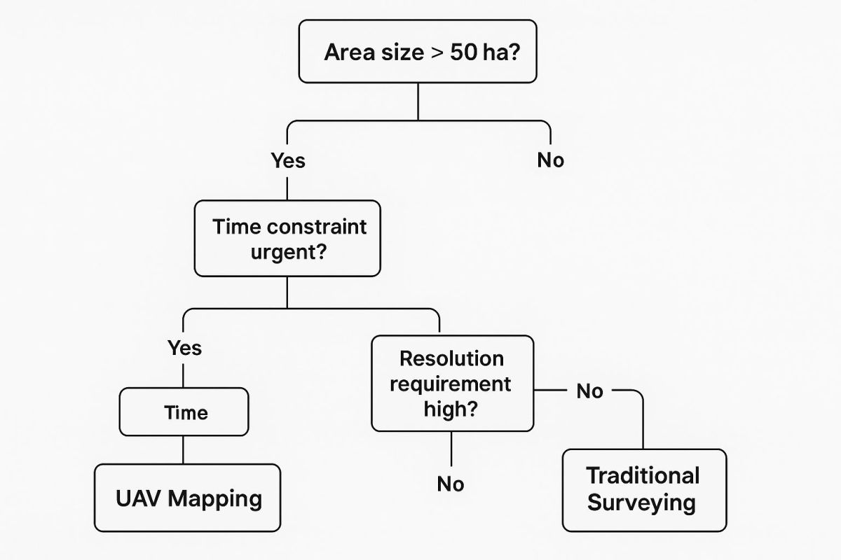
As you can see, UAVs are the clear winner for projects that are large, urgent, or require high-resolution imagery. This process of turning raw drone data into actionable intelligence is a cornerstone of modern geographic information systems. You can dive deeper into the connection between drones and GIS in our detailed guide.
Choosing the Right UAV Platform and Sensors
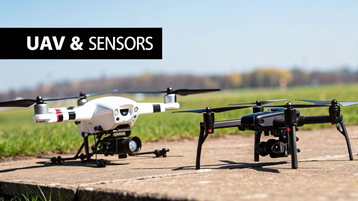
Picking the right drone and sensor for the job is the most important decision you'll make in any mapping project. It’s a bit like choosing the right vehicle and tools. You wouldn't try to haul a tonne of gear in a small hatchback, and you wouldn't use a sledgehammer for delicate work.
It's the same idea with drones. The right UAV for mapping really comes down to the scale and detail your project demands. Get this right from the beginning, and you'll end up with data that's not just accurate, but genuinely useful.
You'll mainly come across two types of drones: fixed-wing and multi-rotor. Each has its own strengths, making one better than the other for certain jobs.
Fixed-Wing Drones: The Endurance Flyers
Fixed-wing UAVs work just like a traditional aeroplane. They need a bit of a runway or a catapult to get going and are built for efficient, forward flight. This design gives them a huge advantage in flight time and the sheer area they can cover.
Picture this: you need to map a massive farm or a long stretch of coastline. A fixed-wing drone can cover hundreds of hectares in a single flight, a task that would be next to impossible for other drone types.
Their efficiency is why they’re the top pick for big projects like precision agriculture, environmental monitoring, and large-scale surveying. Here in Australia, they've become incredibly popular for exactly these kinds of extensive data-gathering jobs.
Multi-Rotor Drones: The Precision Specialists
If a fixed-wing drone is like an aeroplane, a multi-rotor is your helicopter. These drones—usually quadcopters or Quadcopters—use several propellers for lift, letting them take off vertically and just hang there, perfectly stable.
This ability to hover and navigate tight spaces makes them brilliant for detailed, up-close inspections. Think about jobs like surveying a complex construction site, checking a building's facade, or creating a super-detailed 3D model of a small area.
Their flight times are typically shorter than their fixed-wing cousins, but for localised mapping where precision is key, they can't be beaten.
A Quick Comparison
To make the choice clearer, here’s a straightforward breakdown of how these two platforms stack up against each other for mapping purposes.
Fixed-Wing vs Multi-Rotor UAVs for Mapping
| Feature | Fixed-Wing UAV | Multi-Rotor UAV |
|---|---|---|
| Flight Time | Long (1-2+ hours) | Short (20-40 minutes) |
| Area Coverage | Very large (100s of hectares) | Small to medium |
| Takeoff/Landing | Needs a runway or catapult | Vertical (VTOL) |
| Manoeuvrability | Limited; requires forward flight | High; can hover and move in any direction |
| Best For | Large-scale agriculture, long corridors, environmental surveys | Detailed site inspections, 3D modelling, complex areas |
| Cost | Generally higher initial investment | More affordable options available |
Ultimately, the best platform depends entirely on your project's specific needs. For vast, open spaces, a fixed-wing is the clear winner. For detailed, complex sites, a multi-rotor is your go-to.
The Sensor: Your Drone's Eyes
Once you've settled on a drone, the next piece of the puzzle is the sensor. The sensor is what actually captures the data, and different sensors "see" the world in completely different ways.
-
RGB (Red, Green, Blue) Sensors: These are basically high-quality digital cameras. Think of the one in your smartphone, but on a whole other level. They capture images just as our eyes see them, making them perfect for creating detailed, photo-realistic maps and 3D models.
-
Multispectral Sensors: These specialised sensors pick up light from specific bands across the electromagnetic spectrum that we can't see. This is incredibly useful in agriculture, as they can reveal vital information about crop health, water stress, and soil conditions long before any problems become visible to the naked eye.
-
LiDAR (Light Detection and Ranging) Sensors: Instead of just capturing light, LiDAR sensors shoot out rapid pulses of laser light and measure how long it takes for them to bounce back. This process builds an incredibly precise 3D map called a "point cloud," showing the terrain and everything on it. LiDAR is the gold standard for creating highly accurate elevation models and can even see through trees to map the ground beneath a forest. If you're curious about this technology, you'll find that LiDAR drones are used for precise surveys in a huge range of applications.
Planning Your Mission for Accurate Data Capture

Any successful mapping flight comes down to great preparation. It’s a lot like how a professional photographer sets up a shot—they don't just show up and start snapping pictures. They’ll carefully consider the light, the angle, and all their settings to get that perfect image. Planning a mission for a UAV for mapping is exactly the same; the quality of your final map is locked in long before the drone’s rotors even start spinning.
This whole process relies on specialised software to build an automated flight path. We’re not talking about manually flying the drone with a joystick here. Instead, you define the exact area you need to map on a screen, and the software creates an efficient grid pattern for the drone to follow, guaranteeing you get complete and consistent coverage. Getting this right is everything, as it ensures the data you collect is reliable, accurate, and ready for the next step.
Mastering Your Flight Planning Software
Flight planning software is really the brains of the operation. It takes your project goals and turns them into a clear set of instructions the drone can follow. These tools let you fine-tune every part of the mission, from the flight path itself to the camera settings, making sure you capture exactly the data you need. We dive deeper into the different kinds of UAV flight planning software in our dedicated guide.
There are a few key parameters inside this software that will directly impact the quality of your map.
- Flight Altitude: This is simply how high the drone flies. Flying lower gets you closer to the action, giving you more detailed images. The trade-off? The drone covers less ground, so the mission takes longer.
- Image Overlap: This setting dictates how much each photo overlaps with the ones around it. You need a high overlap—usually around 70-80%—for the photogrammetry software to properly stitch all the individual images into one seamless map.
- Flight Speed: A slower, more deliberate flight speed gives the camera’s sensor more time to capture light and seriously reduces motion blur. The result is sharper, higher-quality photos.
Finding the sweet spot with these settings is a bit of a balancing act. You're constantly trading detail for efficiency. A low, slow flight with high overlap will give you stunningly detailed data, but it’ll chew through batteries and keep you in the field much longer.
A key concept you'll hear a lot about is Ground Sample Distance (GSD). In simple terms, GSD is just the real-world size represented by a single pixel in your drone images. A lower flight altitude gives you a smaller GSD—say, 2 cm per pixel—which means your final map will have a much higher resolution and show incredibly fine details.
The Importance of Ground Control Points
While flight planning software automates the drone's path perfectly, there's another piece to the puzzle if you need survey-grade accuracy: Ground Control Points (GCPs). These are physical markers you place on the ground throughout your survey area, and their exact real-world coordinates are measured with high-precision GPS equipment.
Think of GCPs as anchors for your map. The drone captures images of these markers as it flies its mission. Later, when you're processing the data, you can tell the software, "This specific pixel in this photo corresponds to these exact coordinates on Earth." This process effectively pins your digital map to the real world, correcting any tiny GPS errors from the drone and massively boosting the map's absolute accuracy. Without GCPs, your map might look fantastic, but it could be shifted by several metres from its true position.
Aligning with Australian Innovations
Here in Australia, mission planning is getting smarter all the time. Advances in artificial intelligence (AI) and automation are pushing the boundaries of what mapping drones can achieve. Operations beyond the pilot’s line of sight, known as Beyond Visual Line of Sight (BVLOS), are becoming more common, allowing UAVs to efficiently map huge, remote areas for industries like mining and agriculture.
AI is now helping these drones automatically detect and avoid obstacles while making flight path adjustments on the fly, which improves both the accuracy and safety of the entire mission. By carefully planning your flight parameters and using GCPs where needed, you lay a solid foundation for your whole project. This preparation ensures the data you spend time and money collecting isn't just visually impressive but is also geographically precise and ready to be turned into valuable insights.
Turning Raw Drone Images Into Actionable Insights
So, your drone has landed safely after its flight, leaving you with a memory card full of hundreds, sometimes even thousands, of individual photos. How do you turn that digital jigsaw puzzle into a single, seamless map or a detailed 3D model?
The magic behind it all is a process called photogrammetry.
Think about how your own eyes work. Your brain takes the slightly different images from each eye and effortlessly combines them to give you depth perception—a three-dimensional view of the world. Photogrammetry software does a similar thing, just on a much bigger scale. It finds common points across all those overlapping photos from your UAV for mapping and uses them to stitch the entire scene together.
This is how a simple collection of flat images gets transformed into rich, measurable, and incredibly valuable spatial data.
The Core Stages of Photogrammetry
The journey from raw images to a finished map follows a few key stages. While the software does all the heavy lifting, knowing what's happening under the hood helps you understand your data better.
-
Image Alignment: First, the software scans every photo to find common features, or "tie points," in the overlapping areas. It uses these points to work out the exact position and orientation of the camera for every single shot.
-
Dense Point Cloud Generation: With the images aligned, the software creates a dense point cloud. This is essentially a massive collection of millions of tiny points, each with its own precise X, Y, and Z coordinate. It looks like a detailed, coloured, three-dimensional sculpture of the area you surveyed.
-
Mesh and Texture Creation: Next, the software connects the dots in the point cloud to create a 3D mesh, forming a continuous surface like a digital skin stretched over a wireframe. It then drapes the original photo colours over this mesh, bringing a photo-realistic 3D model to life.
To handle the immense computational load required to transform raw drone images into precise 3D models, you really need powerful workstations for precise 3D design processes. These systems are built to generate these detailed outputs without breaking a sweat.
From 3D Models to 2D Maps
A 3D model is impressive, but for many jobs, what you really need is a highly accurate 2D map. This is where the final, and often most useful, data products are created.
The real power of a UAV for mapping isn't just in the pictures it takes, but in the measurable, georeferenced data it creates. These outputs let you move beyond just looking at a picture and start analysing, measuring, and making informed decisions.
The two main outputs you'll be working with are:
-
Orthomosaic Map: This is way more than just a picture taken from above. It’s a high-resolution, geometrically corrected map where every single pixel is in its true geographic position. This means you can take accurate measurements of distances and areas directly from the map, which is impossible with a standard aerial photo because of perspective distortion.
-
Digital Elevation Model (DEM): A DEM is a map that only shows terrain elevation. It strips away all the visual clutter like trees and buildings, leaving you with a "bare-earth" model of the landscape. They are often colour-coded, with different colours representing different heights, making it easy to see slopes, drainage patterns, and topography at a glance. You might also hear about a Digital Surface Model (DSM), which is similar but includes the heights of buildings and vegetation.
These are the final products that deliver the real-world value—the actionable insights you can use to calculate stockpile volumes on a mine site, analyse water flow on a farm, or track progress on a construction project.
Real-World Applications of UAV Mapping in Australia

The real power of a UAV for mapping isn’t just in the tech specs; it’s about what it can do to solve real problems on the ground. Across Australia, from the rich farming country of the Riverina to the enormous mine sites of the Pilbara, drones are delivering data that saves time, cuts costs, and makes work safer.
These aren't just buzzwords. They are tangible results that are fundamentally changing how our biggest industries get things done.
When you see how this technology is being used day-to-day, all the concepts—platforms, sensors, and data processing—click into place. Let's look at a few examples of how different sectors are putting it to work.
Precision Agriculture in the Riverina
Picture a farmer in the Riverina, managing hundreds of hectares of crops. Traditionally, spotting an irrigation leak or a patch of unhealthy plants meant hours of guesswork, driving around, or walking the fields. It’s slow and you’re bound to miss things.
Now, bring in a UAV for mapping fitted with a multispectral sensor. In a single morning, that drone can fly over the entire property, capturing data far beyond what our eyes can see.
The maps it generates can highlight subtle shifts in plant health, flagging areas suffering from water stress or pest infestations days before they become visible problems. This gives the farmer a chance to act with surgical precision, applying water, fertiliser, or pesticides only where they're needed.
This targeted approach doesn’t just boost crop yields and quality; it leads to massive cost savings. By using resources more efficiently, the farmer cuts down on waste, reduces their environmental impact, and ultimately, makes the farm more profitable.
For instance, an NDVI (Normalised Difference Vegetation Index) map might show one corner of a paddock is underperforming. Instead of treating the whole area, the farmer can go straight to the source and find a blocked irrigator. That’s data-driven farming in a nutshell.
Construction Project Management in Perth
On a sprawling construction site in Perth, the project manager is constantly juggling progress tracking, resource management, and keeping everything on schedule and on budget. Weekly site meetings and manual surveys only ever provide a snapshot. They don’t tell the whole story.
By flying a UAV for mapping over the site every week, the project manager gets a complete, high-resolution bird's-eye view. These regular flights create a crystal-clear visual timeline, documenting progress in a way that leaves no room for argument.
These orthomosaic maps and 3D models become indispensable tools for:
- Tracking Progress: Stakeholders can literally see the site evolving week-on-week, confirming that work is hitting its targets.
- Calculating Earthworks: Using the drone's elevation data, the team can accurately measure cut-and-fill volumes. This ensures contractors are paid correctly and soil is managed efficiently.
- Improving Site Safety: Drones can spot potential hazards from above, check that site access is secure, and inspect high or hard-to-reach structures without sending a person into a risky situation.
This steady stream of reliable data makes communication between the site crew, clients, and investors so much smoother. It helps resolve disputes over progress claims before they even start and creates a bulletproof digital record of the entire project.
Mining Operations in the Pilbara
In the harsh environment of a Pilbara mine, safety and efficiency are everything. Tasks like measuring massive iron ore stockpiles or checking the stability of towering pit walls have always been time-consuming and dangerous to do by hand.
This is where a UAV for mapping, often carrying a LiDAR sensor, has been a game-changer. A drone can fly over a stockpile in minutes, creating a precise 3D model that can be used to calculate its volume with an accuracy of over 99%.
A job that once took a survey team half a day in a high-traffic, potentially hazardous area can now be done by a remote operator in less than an hour, safely from the sidelines.
Drones are also crucial for safety monitoring. Regular flights along the highwalls of an open-cut mine can detect tiny movements in the rock face, identifying potential instabilities long before they could lead to a catastrophic collapse. This proactive approach to geotechnical monitoring has dramatically improved site safety. The ability to collect such detailed information from a safe distance has made the UAV for mapping an essential tool for any modern Australian mining operation.
Right, let's talk about the rules for flying drones in Australia, because it’s not as simple as just sending your drone up and hoping for the best. When you're flying for a mapping job, you're playing in the big leagues, and that means following the rules set by the Civil Aviation Safety Authority (CASA).
First things first, you need to understand that flying a drone for work is a whole different ball game to flying it for fun. The moment you use a UAV for mapping or any other commercial reason, you're no longer just a hobbyist. You’re a commercial operator, and CASA has a specific set of rules to make sure everyone stays safe.
Getting to Grips with Your Responsibilities
CASA has a few different pathways for commercial drone operators. You might have heard of the Excluded Category, which lets you do some very basic commercial work with a small drone (under 2kg). But honestly, it's pretty restrictive for serious mapping. You have to stay at least 30 metres away from people and you can't fly over busy areas, which rules out a lot of professional jobs.
For any serious mapping work, you're going to need to move past the Excluded Category. Professional projects just demand the kind of flexibility and permissions you only get with proper certification. It's about keeping your work both legal and safe.
This is where getting qualified comes in. The starting point for you as a pilot is a Remote Pilot Licence (RePL). Think of it as your personal driver's licence for drones—it proves you know the rules and can fly safely. But for a business, a RePL on its own often isn't enough.
The Right Licences for Professional Work
If you're planning to run a professional drone mapping business, you'll almost certainly need a RPA Operator’s Certificate (ReOC). This certificate isn’t for you, it's for your business. It shows CASA you have solid safety procedures, risk management plans, and proper operational manuals in place.
Having a ReOC is what unlocks the ability to take on more complex projects. It’s the key to getting permission to fly closer to people or operate in controlled airspace—things you’ll definitely need to do for many mapping jobs.
Beyond just ticking the regulatory boxes, it's the professional habits that really count. Always run through your pre-flight checklists, keep a close eye on your battery life, and respect people's privacy. A quick chat with residents before flying over their property goes a long way. Getting the rules right and building these good habits is what will set your drone mapping business up for long-term success.
Answering Your UAV Mapping Questions
Diving into the world of drone mapping often brings up a few common questions, especially for those new to the field. Let's tackle some of the queries we hear most often from professionals across Australia, clearing up the key concepts to get you started on the right foot.
What’s the Difference Between RTK and PPK?
Think of Real-Time Kinematic (RTK) and Post-Processed Kinematic (PPK) as two distinct paths to achieving survey-grade accuracy with a UAV for mapping. The core difference lies in when the drone's location data gets corrected.
RTK corrects the drone’s position in real-time while it's in the air. This requires a stable data link to a ground-based station. It’s almost like having a live navigator constantly whispering precise location adjustments to the drone during its flight.
PPK works a bit differently. It logs all the raw satellite data onboard the drone and corrects it after the flight, using data from a base station. This approach is a lifesaver in areas with patchy signal, since you don't need that constant live connection. While both methods deliver incredible accuracy, PPK gives you a reliable fallback if the real-time link ever drops out.
Key Takeaway: RTK gives you instant corrections during the flight. PPK applies corrections after the mission is done. Many top-tier systems actually record data for both, giving you the best of both worlds.
How Accurate Can UAV Mapping Actually Be?
The level of accuracy you get really boils down to your gear and your process. If you’re using a standard consumer drone with its built-in GPS, you’re probably looking at an accuracy of a few metres.
But when you step up to a professional UAV for mapping that has RTK or PPK technology and you use Ground Control Points (GCPs), the game changes completely. It’s not uncommon to achieve an absolute accuracy of 2-5 centimetres. That’s the kind of precision needed for serious surveying and engineering work.
What is Ground Sample Distance (GSD)?
Ground Sample Distance, or GSD, is one of the most important ideas in aerial mapping. Simply put, it's the real-world size covered by a single pixel in your drone photos. For instance, a GSD of 2 cm/pixel means that one tiny pixel in your image represents a 2 cm by 2 cm square on the ground.
A smaller GSD gives you a higher-resolution map, letting you see much finer details. The easiest way to get a smaller GSD is to fly your drone at a lower altitude. The right GSD always depends on the job; a detailed construction site survey might demand a 1 cm GSD, whereas a large-scale agricultural analysis could be perfectly fine with 10 cm.
Ready to take your mapping to the next level? At Innoflight International, we offer advanced UAV solutions built for precision, reliability, and top-tier performance. Explore our systems and discover how we can help make your next project a success.